

HOUSING ZONING ATLAS
The Housing Zoning Atlas is a tool that translates complex, local zoning codes into clear, standardized, and easily understandable data and maps. It helps visualize how land can be used and what types of housing or development are allowed across different communities. It helps identify zoning barriers to housing and other land uses and supports efforts to create more equitable and efficient land use policies. A zoning atlas combines each community’s ordinance text and spatial data about zoning boundaries into a single interactive map. This makes new analyses possible. In short: The NZA is an online, interactive map documenting information about zoning.
The Northwest Michigan Zoning Atlas is part of the National Zoning Atlas (NZA) and reflects a regional effort led by Housing North to make zoning data accessible, comparable, and actionable for housing planning.
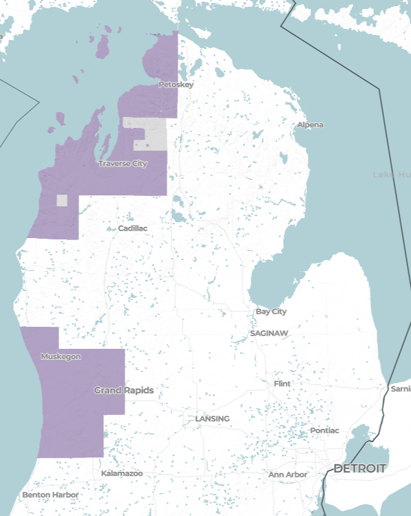
The Northwest Michigan Zoning Atlas includes complete zoning data for eight counties: Antrim, Benzie, Charlevoix, Emmet, Grand Traverse, Kalkaska, Leelanau, and Manistee.
Project milestones include:
Pilot launch in Grand Traverse County (Q1 2025) supported by the Grand Traverse County Economic Development Association.
Emmet County (Q2, 2025) - supported by the Petoskey-Harbor Springs Area Community Foundation, City of Petoskey, Emmet County, and an anonymous donor.
Benzie, Leelanau, Antrim, and Kalkaska Counties completed (Q3 2025) supported by a grant from MSHDA, Huntington, and Rotary Charities of Traverse City.
Charlevoix and Manistee Counties completed (Q4 2025) - supported by the Charlevoix County Community Foundation and the Manistee County Community Foundation.
Access presentation materials, handouts, and other resources created as part of the Northwest Michigan Zoning Atlas to support learning, engagement, and information sharing.
VIDEO RESOURCES
Northwest Michigan Housing Zoning Atlas Overview
Housing Zoning Atlas - Emmet County Open House
Housing Zoning Atlas - Leelanau County Open House
Zoning regulations shape:
What types of housing can be built
Where housing is allowed
The scale, density, and feasibility of development
The time and cost required to bring projects forward
By translating complex zoning codes into clear data, the Zoning Atlas helps communities better understand how local rules influence housing supply, affordability, and development patterns—and where opportunities for improvement exist.
What the Data Helps Communities do
-
Identify where unused legal capacity already exists
Understand project feasibility across jurisdictions
Make zoning rules more accessible to small-scale and local developers
-
Identify areas where zoning supports Missing Middle housing
Inform the creation of Attainable Housing Districts, Neighborhood Enterprise Zones (NEZs), and other incentive programs
Align zoning with housing plans and funding opportunities
How the Northwest Michigan Zoning Atlas Is Built
The National Zoning Atlas follows a standardized methodology nationwide.
Each jurisdiction is analyzed through:
Text Analysis: Reviewing zoning ordinances to extract housing-related rules (allowed housing types, lot sizes, parking mandates, ADUs, public process requirements, and more).
Geospatial Analysis: Digitizing zoning maps to align zoning districts with geographic boundaries.
These two workstreams are integrated into an interactive map and database, enabling consistent comparisons across jurisdictions and counties
Regional Coverage & Progress
The Northwest Michigan Zoning Atlas includes complete zoning data for seven counties:
Antrim, Benzie, Charlevoix, Emmet, Grand Traverse, Kalkaska, and Leelanau.
Across the region:
122 jurisdictions reviewed
23,298 pages of zoning code analyzed
1,582 zoning districts documented
Approximately 200 standardized data points per district
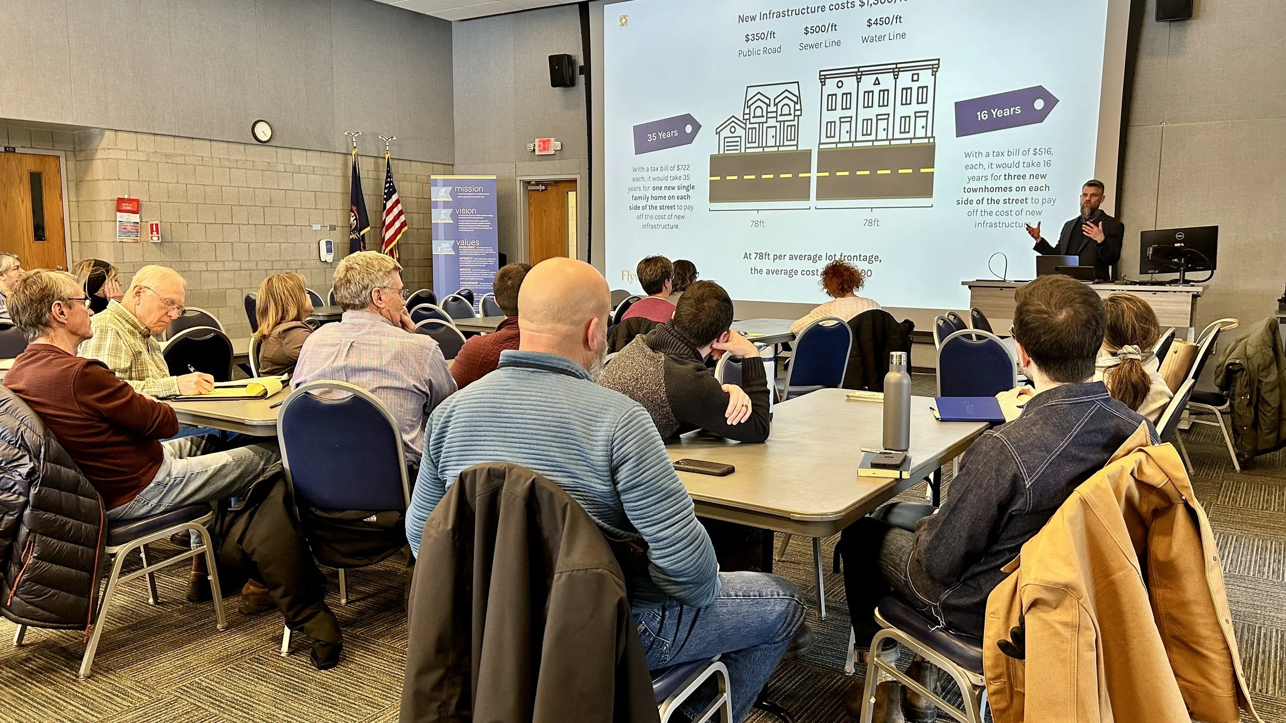
Grand Traverse County Housing Growth Opportunity Map
This interactive planning tool helps communities understand where housing can be built most efficiently and responsibly in Grand Traverse County. Developed in partnership with Grand Traverse County, Housing North, and Flywheel, the Housing Growth Opportunity Map identifies areas best suited for residential development based on access to existing roads, water, and sewer infrastructure, helping reduce costs and streamline early planning.
The map also prioritizes environmental stewardship by excluding protected lands and areas with natural constraints such as wetlands and steep slopes. Designed for municipal leaders, planners, developers, and community stakeholders, this resource supports data-informed decision-making and collaborative, sustainable housing solutions across the region. For more information about the GT County Housing Opportunity map, please contact Susan Leithauser-Yee at leityee@gmail.com.
The Northwest Michigan Zoning Atlas is made possible through the generous support and collaboration of regional and statewide partners committed to advancing data-informed housing solutions.
This project is led by Housing North, in partnership with the National Zoning Atlas, and is supported by local, regional, and statewide partners who recognize the importance of clear, accessible zoning data in addressing housing challenges across Northwest Michigan.
Key project partners include the Michigan Association of Planning, which collaborated with Housing North to help launch the program; Flywheel Companies, which supported community planning projects in Emmet and Grand Traverse Counties; and Land Use Atlas, the organization that created the National Zoning Atlas platform that underpins this work. We gratefully acknowledge the additional regional and local funders whose support helps make the Northwest Michigan Zoning Atlas possible:


Housing North & the Housing Zoning Atlas
Housing North partnered with the National Zoning Atlas to bring clear, standardized zoning data to Northwest Michigan helping communities better understand how local land-use rules shape housing opportunities and constraints. While the National Zoning Atlas provides the national framework and technical methodology, Housing North leads the regional implementation, ensuring the data is complete, relevant, and useful for local decision-makers.
Housing North’s role is not to set zoning policy, but to translate complex zoning information into practical tools that support housing planning, collaboration, and implementation. By convening partners, coordinating data across jurisdictions, and connecting zoning insights to real-world housing strategies, Housing North helps communities move from information to action.
Through the Northwest Michigan Housing Zoning Atlas, Housing North:
Ensures zoning data across the region is consistent, transparent, and accessible
Helps communities identify where housing capacity already exists under current zoning
Supports planning for Missing Middle housing, attainable housing districts, and incentive-based development tools
Aligns zoning data with regional and statewide housing priorities
Provides a shared foundation for collaboration across local governments, nonprofits, developers, and residents
The Northwest Michigan Zoning Atlas is a living tool, and 2026 will focus on deepening local engagement, expanding access, and supporting communities as they turn data into action.
Looking ahead to 2026:
Outreach and Education: Community-based outreach and education efforts will share local Housing Zoning Atlas (HZA) results and support understanding of zoning barriers and opportunities.
Q1 2026 – Grand Traverse County: A Growth Corridor open house to share findings from Grand Traverse County’s project using the Housing Zoning Atlas.
Emmet County: Launch of Emmet County’s Community Planning project, using the HZA to inform local housing strategies.
Q2 2026 – Tools & Access: Development of links and interactive maps for County and Housing North websites to make zoning data easier to explore and use.
Future Expansion: Fundraising and partnership development for potential HZA expansion in Wexford and Missaukee Counties, pending community interest.
Ongoing Updates: The Housing Zoning Atlas will be reviewed and updated annually to reflect zoning changes and new data.
Interested in participating, hosting a community conversation, or supporting the Housing Zoning Atlas? Email us at info@housingnorth.org!